written and photographed by Jeffrey L. Peachin and Kristin Byrd
Sep 2000, Vol. 4 No. 11
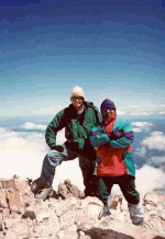
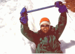 Three of us stood on the 14,200-foot summit of Mt. Shasta and cheered. We saluted our mountaineering achievement by alternating raising our ice axes then snapping photographs of the scenic valley, landscaped with sulfur lakes and the crevassed glaciers of Bolam, Hotlum, Wintun, Whitney, and Konwakitom. After signing the summit book, we descended back down the trail until the snow was soft enough to glissade the next three hours to our base camp at 9,000-feet.
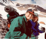 Twelve of us had taken on this weekend challenge after a brief stop in Shasta City to rent heavy boots, crampons, ice axes, and helmets. We knew we would be camping above the snow line, and we were prepared to strike an ice camp.
It had taken us about four hours to climb the steep terrain called the “heart” of Mt. Shasta The designated campgrounds of “50-50” and Helen Lake were already occupied, so we continued along the trail until we found a suitable site. Several in our group yielded to the steepness, bagging the climb to spend the weekend at a comfortable hotel in Shasta City.
 After a not-so wonderful “freeze-dried” dinner, the rest of us had a bad night’s sleep. The snow-covered ground was cold and uneven. The majority of our group had never experienced a snow camp, and even with warm sleeping bags and pads, the ground felt hard and cold. The high elevation did not make sleep come easy.
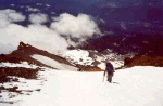
 The sun rises early during summer months in Northern California, so our 4 AM summit climb was not hindered by darkness. Our nine-hour trek passed through the red rock boulders of Red Banks, before reaching an ascent named “Misery” hill.
The day was clear, and occasionally we would get a whiff of sulphur from the lakes below. We could see nearby landmarks Mt. Lassen and Lake Shasta. While this was by no means a Mt. Everest-type climb, our mountaineering experience made us feel as if we were on “top on the world.”
 Our effort was well worth it, not only for the personal achievement, but also the fun of being able to glissade down the mountain. Sitting on our behinds, we used the ice ax like a canoe paddle, it controlled the path of our descent. If our speed seemed out of control, we rolled over on our bellies, making an “emergency arrest,” by digging the ax into the snow to stop the descent. It was hard to believe that the summit took 9 hours to climb and 3 hours to descend by glissade.
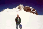
We had one more night of ice camping with another freeze-dried meal before we hiked four hours back to the trailhead. Mt. Shasta may not be a technical climb, but its steep pitch and 14,200 foot elevation, makes it a challenging climb for experienced mountaineers.
Backpacking the “Lost Coast” of King’s Ridge National Preserve
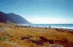
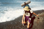
 Two hundred miles north of San Francisco, Pacific Coast Highway (U.S. 1) veers away from its scenic route along the coastline. The deviation leaves twenty-five miles of isolated beach untouched by highway traffic. This California anomaly called the King Range National Conservation Area is better known as “The Lost Coast.” Its isolation makes it a great destination for weekend backpacking and camping.
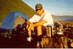
In the beachfront settlement of Shelter Cove, a shuttle service drove us north to the town of Petrolia, where we headed east on foot to the coastline. Traveling south along this route allows the prevailing winds to be at your back. During our weekend trip, we saw a total of about two dozen hikers. Hikers entering from the south entrance were making day trips into the area and many carried surfboards on their packs
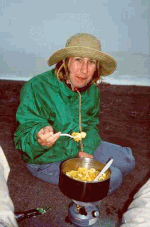
 The first night we camped on a sheltered beach where we enjoyed magnificent views of the Pacific Ocean. No campfires are permitted in the park, so we cooked a backpacker’s gourmet dinner of pasta with pesto (in a tube), a loaf of French bread, we roasted s’mores (chocolate, marshmallows, and graham crackers) on our backpacking stove.
The next morning as we waited for the fog to lift, we ate a not-so-gourmet Poptart breakfast. August and September are the best months for this trip. The rest of the year can get foggy, windy, cold and stormy. Hiking on loose sand along this beach route makes the going slower than a packed trail.
 We took our time along the trail and watched sea lions play in the surf. We explored tidal pools filled with mussels, sea urchins, and anemones. In the midst of this isolated coastline, we walked by several houses “grandfathered” into the preserve; one house is accessible only by small aircraft landing on its private dirt airstrip.
The day was clear and beautiful. We stopped at several streams to purify drinking water and took advantage of the fresh water to refresh and clean up. We ate the remaining loaf of bread with sausage and cheese. After hiking about twelve miles, we settled again for the night.
 Our final seven miles were more challenging. The trail follows the beach and we were at the mercy of the tides. We were glad that we brought along a tidal chart. Portions of the trail are inaccessible during high tide. At one point we waited about 40 minutes for the tide to ebb. Spotting a trough in the surf, we ran around the point to higher and dry beachfront. Arriving at Blacks Beach, a wide lava beach with pounding surf, we reached the end of the trail.
We found the car where we had left it in Shelter Cove. As we headed back towards San Francisco, we were quickly engulfed in the gridlock of traffic.