Text and photos by Mary L.Peachin
March, April, 2017, Vol. 21, No. 5
Orcas were swimming on the starboard, port and forward of the ship. A killer whale pod swam, breeched, and frolicked as we circled them. The scene was a great example of a food chain feeding frenzy. Diving White Gannets bombed the water for fish leftovers. What a fitting finale to our journey around Iceland.
 Less than three hours after departing Reykjavik port, the Explorer sighted humpbacks. Spouting air as they surfaced, they feasted on herring scraps left by diving Arctic Terns. Our cabin window provided an incredible view of this fascinating whale scene.
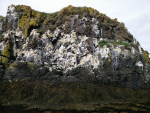
Overnight we motored to Iceland’s southwest peninsula. The steep, dramatic, basalt cliff of Látrabjarg are home to many species of seabirds: Puffins, Guillemots, Cormorants, Northern Gannets, Fulmars, Gulls, Kittiwakes, and 40 % of the world’s population of Razorbills. Europe’s largest bird cliff, it is more than two miles long rising to almost three feet tall.
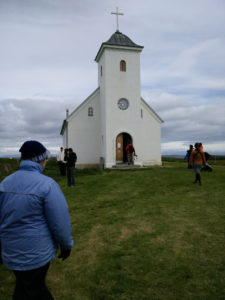
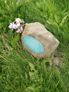
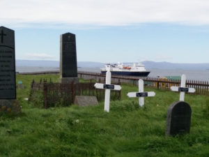
A wet landing by zodiac on Flatey Island’s volcanic topography provided our first hiking opportunity. After departing Breidafiord landing we explored a hilltop cemetery followed by a historic Lutheran church. Less than two miles, the trail Lundaberg cliffs provided great views of Puffins, more swooping Arctic Terns, and Kittiwakes.
Boarding the zodiac to return to the ship, we stopped for a closer view of nesting Kittiwakes, most with chicks, Fulmars, Puffins, Eider Ducks, famous for their down, and Arctic Terns, known for their long (70,000 k) migration.
 A second afternoon hike provided more bird species: Fulmar, Arctic Tern and Skua, Redwing, Redshank, Purple Sandpiper, and colorful red-billed Oyster Catchers.
Dynjandi or Fjalifoss “Mountain Falls,” located in remote Westfiords, is a series of seven “thunderous“waterfalls. Calm waters in the surrounding fjord provided an opportunity to kayak. We embraced the cool freshness and close up water view.
Vigur Island, the second largest island in Isafiodur Bay, is inhabited by a farming family who earn their livelihood by fishing, collecting eggs, raising sheep and harvesting treasured Eiderdown, a tedious and costly effort. A large colony of Arctic Tern and Puffin inhabit their island.
Eyjafjallajökull Glacier, located north of Skógar and west of Mýrdalsjökull, is one of Iceland’s smaller ice caps. The 5,417 foot ice cap covers the caldera of a volcano which has frequently erupted since the last glacial period.
In April, 2010 Eyjafjallajökull erupted from the top crater in the center of the glacier, causing jökulhlaup or meltwater floods in nearby rivers. This required the evacuation of eight hundred residents. It was estimated to be as much as twenty times larger than previous ones. A second eruption scattered volcanic ash several miles into the atmosphere. This caused air travel disruption in northwest Europe for almost a week.
 Cruising by Ísafjörður, which translates to ice fjord, this northwest town, located on a sand spit on the peninsula of Vestfirðir (Westfjords) is one of the country’s largest fisheries. In recent years, the city has become a tourist destination serviced by ferries.
A tour on the mainland took us through a dark single five mile tunnel to Skruour. Directional rules of the road provide sporadic widenings for yielding the right of way to oncoming vehicles.
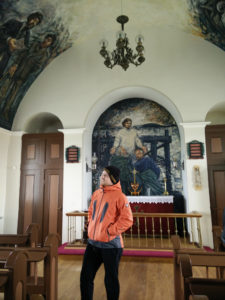
Prior to visiting Flateyri, we stopped to view Iceland’s original botanical garden. Built in 1909, its blue, yellow, and brilliant red poppies were brilliant. After a brief visit to a third generation bookstore, where books were sold by the pound, and a small bakery, a young gal sang for us in a small church. Formerly a fishing village, one popular export remains dried cod heads which are sold to the Far East. We had the option to hike to Arctic Fox Center along Valagil trail, or take a walking tour through the back streets of Isafjorour.
 Siglufjörður Herring Museum is the location where Norwegians taught Icelanders to fish and salt herring. During the short summer season, “herring girls,” paid by the barrel, worked thirty hours cleaning, salting, and barreling. For each barrel, the girls received a coin which they placed in their boots. During weekly pay day their collection was converted to kroners.
During harvest, fishing boats might have to wait as long as a few hours to several days to unload. The fish were separated by freshness and size. The less desirable were made into meal or oil.
In Iceland’s longest sixty mile fiord, the northern village of Akureyri is Iceland’s second (18,000 population) largest city, approximately a six iron from the Arctic Circle. The village has quaint cafes and fine restaurants. It is a place where locals and visitors party late into the night. Rub 23 features century old Robata, a method of grilling used by Hokkaido, Japan fisherman. Lystigardurinn, the most northerly botanical garden, has the largest display of high latitude plants.
In the year 1,000, approximately 400 Icelandic Norse, considered pagans by the church, were converted to Christianity by missionaries. This conversion resulted in tossing pagan statutes into twenty four foot deep Goðafoss, known as waterfall of the Gods. Flowing approximately two hundred miles to Skjálfandafljót, it is one of Iceland’s longest glacial rivers.
 Mývatn is a shallow lake surrounding wetlands located in an active volcanism area not far from Krafla volcano. Populated with a rich fauna of water birds including Common species including Barrow’s Goldeneye, Red-breasted Merganser, Wigeon, Gadwall, Mallard, Common Scoter, Long-tail Duck and Eurasian Teal.
The area overlooks almost a dozen pseudo craters formed from ice erosion. Two major types of basaltic lava flow, known by their Hawaiian terms as a’a and pahoehoe, have created deep cracked fissure faults, some which still vent steam. The magma or molten rock create table rocks when volcanoes erupt through snow. Locals use grass covered with sheep dung on small building used for smoking fish.
Grjtagja was once a popular steaming 140 degree (60 Celsius) bathing spot. Once owned by the owned by Vogar farm, pools for men and women were used for nude bathing. Stunted larch trees were surrounded by colored fields of blue lupine while barren soil areas, caused by toxic volcanic Sulphur and iron, were a stark contrast.
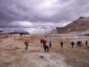
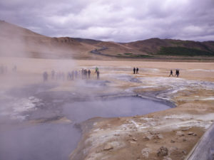
Námafjall, a high temperature geothermal area, is filled with streaming mud pots. When water is in short supply, the mud turns to clay, and steaming fumaroles. Plunging as deep as 3,000 feet, they become colorful as drying temperatures reach 420 degrees (200 Celsius). Centuries ago the chemicals produce gun powder.
Heading to long northeast peninsula of Laganes, near Skoruvikurbjarg and Skalavikurbjarg, we cruised through the currents of both the Gulf Stream and East Greenland or Irminger North Atlantic Current. Langanes, a narrow peninsula between Þistilfjordur and Bakkafloi, is shaped like a large goose head. This region is also known for rich bird life, especially for viewing Gannets and Brünnichs Guillermot from land. Ocean conditions make for excellent fishing. The hamlet of Skalar has now been abandoned making the area relatively isolated.
 During a zodiac tour we were greeted by ship staff dressed like Vikings but serving hot chocolate. Fulmars nested in rocks and fed in the water.
For visitors who enjoy fresh cod and salmon. Icelanders enjoy a different variety of food than the tourists who visit. Much of it is smoked with sheep dung or preserved. Icelandic food includes fermented shark, reindeer, lamb or hangikjot served with flatbred, dried cod and haddock, puffin, and sheep’s head. These dishes are typically served with Brennivin, known as Black Death, a spirit distilled with potato and a high volume of alcohol.
Djúpivogur small harbor is the oldest port in the Eastfiords. Offshore Papey Island, was thought to once be a hermitage for Irish Monks until the arrival of the Norse. More recently used as a farm, its cliffs are covered with nesting birds. Burrowing Puffins, members of the Auk family, are becoming endangered. Thy do not have enough food to enable breeding. The Northern Hemisphere’s version of a Penguin, they share the cliffs with Oystercatchers, Razorbills, and Common and Black Guillemots. Neighboring Fulmars are known to spit a greasy substance. Chubby spotted grey and harbor seals swim playfully.
 Other than several campers, the Hellisbjarg lighthouse and Iceland’s oldest and smallest church dominate Papey Island. Walking along a track lined with cotton grass and sedge is often muddy.
In 1963, Surtsey erupted almost 150 feet beneath the ocean’s surface. These undersea vents created a stark, vegetated basalt island that is considered part of the Mid-Atlantic Ridge.
Our last stop was Heimaey or Home Island. It is the largest island in the Vestmannaeyjar archipelago, and the largest and most populated island off the Icelandic coast. Its 4,500 inhabitants watched Mount Eldfell erupt in 1973. By continually spraying seawater on the lava flow, they saved their harbor, the most important part of their economy.
As our circumnavigation came to an end, the Captain announced “killer whales.” Gannets, diving in all directions, surrounded the female orcas with calves and males identifiable by their larger, unique fin. It was a fitting way to end the cruise: humpbacks leaving, orcas on our return topped by lots of bird watching and admiring geothermal activity.