As told to Mary L. Peachin, photos courtesy of Janice Hanson and the Arizona Office of Tourism
Vol. 11 No. 1
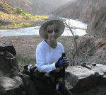
“It was a walk in humility and pride, pain and strength, fear and love. I will forever treasure every step. But, holy cow! It was HARD!-Janice Hanson
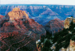
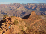
 Just the anticipation of hiking the Grand Canyon non-stop from Rim to Rim to Rim, a distance of 48 miles and twenty thousand feet of elevation change and a time challenge of less than 24 hours, made my stomach flip. My husband Joe and I had arrived at the South Rim early in the afternoon, plenty of time for a look-see at a ledge overlooking the incredibly beautiful chasm. My heart was pounding with excitement and anxiety. Hazy afternoon shadows made the North Rim appear so very far away. As we walked along the paved footpath, we tried to rationalize the distance, any inspiration that would make the span between rims appear closer. No way, this was going to be a very long hike.
After several too-brief hours of sleep, we met our friends, Bill Kimball and David Lovitt, in the Bright Angel parking lot. It was 3:00 in the morning, the temperature was a bone-chilling 38 degrees. Thankfully, the wind was calm. Arriving at the nearby trailhead, we flipped on our headlamps. The beam illuminating the trail was amazingly bright.
The dark silhouette edging the canyon rim lightened about the time we approached Indian Gardens. This small oasis, 3000 feet below the rim, is a perennial water source. Until the early 1900’s, the Havasupai used the area to raise corn, squash and beans. Its stream¸ which parallels the trail to the Canyon’s base at the Colorado River, quenched out thirst. We grabbed a quick snack.
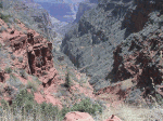
 Winding our way through Devil’s Corkscrew, I dreaded the thought of the challenging ascent we would have to make on our return hike the following night. I tried to convince myself that in the dark it wouldn’t feel as steep. The Corkscrew is a more difficult and potentially dangerous section of Bright Angel Trail. Its switchbacks, when viewed from the South Rim, resemble an enormous corkscrew. During the summer, it is not uncommon for temperatures to reach or exceed 130 degrees.
Moving along at a fast pace, we arrived at the Colorado River, a distance of seven and three quarter miles in three and a half hours. Following the banks of the River for a mile, we crossed the silvery suspension bridge leading to Phantom Ranch. At the Canyon’s only interior lodge, we ate a hearty breakfast and filled our water bottles. Bright Angel Creek was gushing 10 to 15 feet across as we headed to our next stop in Cottonwood Campground. Springtime grasses, shrubs, and wildflowers were in full bloom.
 Permit-required Cottonwood Campground opened into a green valley. Up to this point, the hiking had been fairly easy—mostly downhill and relatively flat along the Colorado River.
Prior to entering The Box, Bill suggested that we cached some of our gear. Items that we wouldn’t need until our nighttime return to Phantom ranch. We unloaded extra clothing and food into a bag, and wedged it between a rock and a small tree near the bank of the creek.
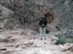
The North Kaibab Trail enters The Box, a seven mile slot canyon, about two miles above Cottonwood Campground. Here, the trail parallels a creek flowing from its source at Roaring Springs before finally merging into the Colorado River. Vertical walls provide shade from the sun, which has to be directly overhead to cast rays into the creek. It might be a reprieve from the scorching heat, but the topography creates a dizzy, seemingly never ending, winding serpentine that appears endless until the trail finally opens up after the last bridge, a mile from Phantom Ranch. As a first time Canyon hiker, I found this section of the trail to be disconcerting. Those repetitive bends made it impossible to gauge the distance I was hiking.
 Regardless, it was one of my favorite segments of the hike. We followed the roaring creek through narrow canyons for several miles. Sheer 600-foot walls enveloped us; the sound of the rushing water was deafening. Sturdy footbridges, crisscrossing the streams, broke the monotony of the dusty trail.
The two-mile hike brought us to the shade-covered ranger station at Aiken’s Place. The was our last opportunity to fill the water bottles for the ascent up to the North Rim and return back to the station.
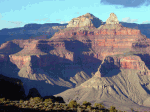
Hitting the trail, the canyon’s incredible scenery distracted my mind from the difficulty of the climb. Towering above us, pine trees dotted the colorful red and white walls of the canyon. We hiked up and up and up.
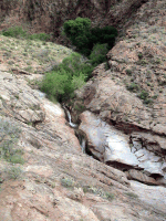
As the trail narrowed, I was grateful for the beauty of waterfalls rushing over rocks then spilling hundreds of feet into the creek below. Suddenly, I had to focus on the trail; just a brief glance over the edge made my head spin.
We passed a sign describing fossils found in the limestone rock along the trail. Looking for ancient creatures that lived in the ocean eons ago kept my mind off the precipitous drop to my right. A greenish layer limestone turned to a rusty color of red rock. The trail was getting steeper, and the sun was blazing. What happen to those clouds and breeze that were forecasted?
 The next waypoint was Supai tunnel, a mere two very steep miles from the North Rim. Beginning to feel weak and shaky, we stopped to gobble some trail mix. Entering a pine forest, veteran climber David assured us that we were getting close to the North Rim. The grueling climb took us past Coconino Overlook. Was this the summit, I hoped? No, I knew better, despite David’s repeated assurances.
Coconino Overlook offers an incredible view of the Canyon, but I was too tired and too eager to reach the North Rim to stop for a look. I told myself, I’ll check it out on the way down. Was it my imagination or did the trail feel slightly less steep? When the trail headed away from the cliff and into the trees, it became difficult to tell how much elevation we were gaining. David continued to encourage us with more of those “we’re almost there” comments. After almost 12 hours of hiking, we reached the North Rim. Unloading our backpacks, we collapsed on the ground taking a break and catching our breath.
 As we ate our lunch, those predicted clouds closed in and the wind picked up. Although it was only 60F degrees, our clothes, soaked with sweat plus the chill factor, made it feel much colder. But, we had no time to spare. It was time for our return, another 12 hours of hiking.
Our brief rest and refueling made us feel surprisingly good. Descending uses different muscles than those that worked so hard getting us to the top. Several long hours later, we again reached The Box. We were closing in on Phantom Ranch. By the time we recovered our cache, the sun was setting. Chowing down at the ranch, we indulged ourselves with a round of icy lemonade, and a change of clothes.
It was time for the final ascent, the return to the South Rim. With a weary sigh of apprehension, as we headed out, I harnessed my backpack. This time the trail to Indian Gardens felt like it took weeks to hike rather than several hours it took us on the way down. It was almost midnight when we collapsed onto the Garden’s wooden benches. We dove into Joe’s personal blend of trail mix—giant cashews and peanut M&Ms. We refilled our water bottles and steeled ourselves for the assault to the summit—four more miles to the South Rim.
 Bill cautioned, “The trail is steep, but there are two rest stops” They would serve as progress markers for the arduous climb. We staggered into the first stop an hour later. Bill’s headlamp dimmed. While he changed batteries, we relished the break. Unfortunately, the plastic latch on the battery compartment broke. Bill was now without a headlamp. It’s extremely difficult to hold a flashlight while using hiking poles. We also discovered that there was no water available at this rest stop. An experienced hiker and Canyon veteran, Bill is tough, and persevered without a headlamp and only one water bottle left for the remainder of the hike.
At the final rest stop, we rationed out our remaining water. This hike was a team effort. We stopped briefly three more times along the trail before we rounded a bend at the top of a switchback and saw a building. Suddenly lights appeared.
 We had made it. It was 2:30 a.m. We had made the 48-mile grueling hike in less than 24 hours. The dozen or so concrete steps from the trailhead into the parking lot felt like a cruel joke. We laughed weakly at the insult. As we stepped into the lighted parking lot, we laughed and shook hands and hugged one another.
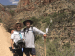
This rim to rim to rim hike was the biggest physical challenge of my life. It was also one of my most beautiful experiences. I learned so much about myself. I discovered that I could train hard for an improbable goal, one that would test the true mettle of my physical and mental abilities. I could achieve any goal I set for myself. I have the utmost respect for my Joe. He is incredibly fit and trained for only six weeks. My friends, Bill and David, who have made this hike several times, willingly put themselves through a very real hell, just so I could share the bonding of this incredible journey. It was a walk in humility and pride, pain and strength, fear and love. I will forever treasure every step. But, holy cow! It was HARD!!!